Choosing a GPS robot mower is easier when you know which features truly change how well it cuts your lawn. Modern models do more than wander randomly. They map your yard, follow precise routes, and avoid obstacles with smart sensors and AI. Some brands even let the mower learn your lawn layout and optimize coverage over time. Key upgrades like RTK GPS, virtual boundaries, and multi-zone control now set the best performers apart. When those tools work together, you get cleaner cuts, fewer missed patches, and less time spent babysitting your mower or fixing its mistakes.
Which GPS Robot Mower Features Have the Biggest Impact on Performance?
RTK GPS Navigation and High-Precision Positioning Systems
RTK GPS navigation gives the robot mower a major boost in accuracy. Standard GPS can drift by several feet, which leads to crooked paths and uncut strips of grass. RTK (Real-Time Kinematic) correction tightens that margin to a few centimeters. The mower always knows exactly where it is on your lawn, even near trees or buildings. This lets it mow in straight, efficient lines rather than random patterns. High-precision positioning also reduces overlap, so the mower uses less time and energy while still covering every area. When paired with wheel sensors and gyroscopes, RTK GPS keeps the mower on track, improving both cut consistency and overall lawn appearance.
Smart Mapping, Virtual Boundaries, and Multi-Zone Management
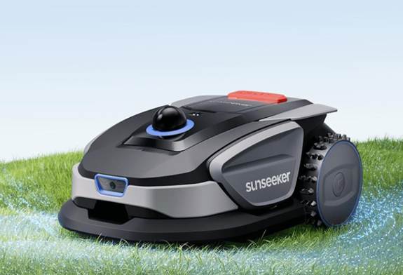
Smart mapping lets the GPS robot mowers build a digital map of your lawn, so it can mow with intent instead of guesswork. It recognizes the lawn shape and key areas, then plans routes around them. Virtual boundaries replace physical perimeter wires, which simplifies setup and later changes. You can use an app to mark no-go zones around flower beds, pools, or gravel. Multi-zone management takes this further. Some models, like Sunseeker Tech GPS robotic lawn mowers, support up to 60 lawn zones and 5 maps for complex properties. That means separate settings for front yards, backyards, and play areas, giving each section custom schedules, cutting heights, and patterns.
AI-Powered Route Planning and Coverage Optimization Technology
AI-powered route planning helps the mower think ahead rather than move randomly. The mower analyzes the lawn map, past mowing data, and real-time location to choose the best route. It reduces repeat passes and avoids tight turns that waste time and wear down the grass. Coverage optimization technology checks which areas the mower has already cut and redirects it to untouched spots. Over several runs, the system learns where the lawn grows faster or where obstacles frequently block its path. Some advanced mowers adjust their route patterns based on that history. This approach leads to even coverage, less energy use, and fewer visible mowing lines or uncut patches.
How Do Advanced Features Improve Mowing Accuracy and Efficiency?
Obstacle Detection, Collision Avoidance, and Real-Time Adaptation
Obstacle detection helps the mower avoid hitting toys, garden furniture, trees, or pets. Sensors such as ultrasonic, radar, cameras, and bumpers scan the area ahead and around the mower. When it detects something, it slows, stops, or steers around the object instead of pushing into it. Collision avoidance protects both the mower and your property. Real-time adaptation takes this further. The mower changes speed, direction, or cutting pattern when it meets slopes, thicker grass, or narrow passages. It can adjust blade speed in dense patches or reroute if a new object blocks its usual path. These smart reactions keep mowing precise and efficient without constant human intervention.
Automatic Charging, Weather Response, and Intelligent Scheduling
Automatic charging keeps the mowing schedule on track with minimal effort. When the battery runs low, the robot mower returns to its base, charges, and resumes the job from where it left off. Weather response features use rain sensors or cloud data to pause mowing when conditions are wet or unsafe. This protects the lawn from ruts and clumping, and it extends blade life. Intelligent scheduling analyzes lawn size, grass growth, and past mow times to suggest or automate mowing sessions. The mower can run more often during peak growth and scale back in cooler or drier seasons. Together, these features deliver consistent results with less time spent on manual planning.
Mobile App Control, Remote Monitoring, and Software Updates
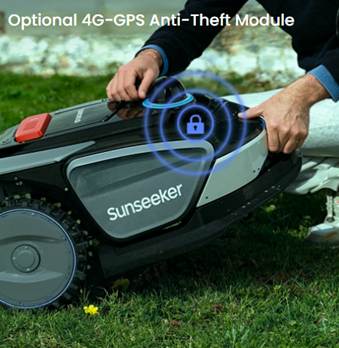
Mobile app control lets you manage the mower from anywhere. You can start, pause, or stop a session, change cutting height, or adjust schedules on the go. Remote monitoring shows real-time location, battery level, and status, so you always know what the mower is doing. If it gets stuck or lifted, you receive alerts and can respond quickly. Software and firmware updates add new features and improve performance over time. Brands often refine navigation, mapping, and safety through over-the-air updates. This means the mower can get smarter after you buy it. App control, live data, and ongoing updates work together to keep the mower efficient, secure, and easy to manage.
Conclusion
The GPS robot mower features that deliver the best results focus on precision, smart planning, and autonomy. RTK GPS and high-precision positioning keep mowing lines straight and coverage consistent. Smart mapping, virtual boundaries, and robust multi-zone support, such as the multi-map options in Sunseeker Tech GPS robotic lawn mowers, tailor performance to varied yards. AI route planning, obstacle detection, and adaptive behavior refine how the mower moves and cuts. Automatic charging, weather-aware scheduling, and app control reduce daily work for the owner. When you combine these tools in one mower, you get a cleaner lawn, less wasted time, and a more reliable mowing routine.